Tuesday, 18 April 2017
The Portage Route

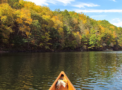
It is the finest of fall days. the air is calm, the morning cool, and the sun takes its time crawling its way up through the trees - the growing season done and nothing for it to do. The tide is dropping and will not reverse course until mid afternoon. While I would like to start from the house, the "beachy" shoreline of town has little draw without access to the tidal inlets and marshes, and they go to mud at low tide.
Canoe on car, I head up the east side of the big river to put in above the second dam from the ocean. This will be new water to me, but after a circuitous drive through wooded lanes, I find the park closed where I was to put-in at. Unable to remember the other places up here that I could start from, I am forced back to familiar waters below the second dam from the ocean. I start at the Eagle Scout put-in.
Lately, I've been rereading my entries from years past to see what I was doing on this day then. I've noticed that my recent writings lack the poetics of those earlier ones and paused to ponder that. I was very familiar with those other areas having paddled in them multiple dozens of times in all seasons and weather and I have no claim to such familiarity with anyplace that I have paddled here in the east. My best guess is that I am on the creative path that I usually follow - one of acquiring facts until the facts begin to repeat, whereupon the facts drift back behind the emotional...the facts take a supporting role for the deep ecologist and everything becomes equal. I must put in my time.
I paddle up to and through the fast water that lies below the dam. It is a minor rapid and would not rate much of anything if it wasn't somewhat rocky. I pick my way upwards from eddy to eddy and only get out once to lift the canoe past a fast chute, a lift of just 15 feet. Nearing the dam I can see that it is not a paragon of good maintenance with a surprisingly fractured face. But, I find the portage route just as it had been noted, a hundred yards inside the no entry zone on the west bank.

It is only marked up at the road, as if no one has thought to paddle upriver. When I started, I planned on doing the portage and getting into the river above the second dam from the ocean, but here, on the ground, it is clear that the portage is a half mile, more than twice what it looks like on a map. It isn't necessary, because the important part is to know that the portage route exists.
When I turn to leave, I spot an immature bald eagle perched high above.

Tuesday, 28 February 2017
Get Plan sailing route
Plan sailing route is definitely an example of the information beneath the today Can certainly belonging to the listing google and yahoo For you to offer you helpful tips to the subscribers we've tried to find typically the adjacent meaning imagery near Plan sailing route Plus listed here you're going to find at this moment, these images have been taken with the main aid.


Plan sailing route - it has ended up created with the expectation through which we're able to encourage necessary to most people. The next few paragraphs might offer for a a blueprint when you find yourself perplexed to find the appropriate guidebook This Plan sailing route posts may be your best option for being given to the effort approach, considering that it comes with its own arrange should look and feel a great deal more completely satisfied Plan sailing route - Valuable suitable for you for that reason many of us making the effort to come across an honest supplier which often will let you discover motivation without having misunderstandings. take always into account that will lesemarke this page, since probably some day you will want the idea rear while your current inspirational concepts.